By Tom Kuglin
RMEF’s quest to conserve elk habitat squares nicely with protecting the integrity of America’s National Historic Trails. And like Lewis and Clark, this alliance is proving to be a powerful duo.
In 2002, Tom Price and his family, owners of Price Cattle Company, decided the time was right to place a 640-acre voluntary conservation agreement (or VCA, also known as a conservation easement) on their ranch south of La Grande, Oregon.
“I donated the easement to the Rocky Mountain Elk Foundation because of the benefit of protecting habitat in perpetuity,” he says. “I believe in conservation easements, and I’m delighted the Elk Foundation does them.”
Their land is a mosaic of native forests dominated by Ponderosa pine, shrublands of sagebrush and willowy creek bottoms that combine to provide forage and cover for the area’s bountiful wildlife. While the VCA does not include public access, it forever protects essential spring and summer range for elk and deer, including calving and fawning grounds, while also maintaining the land as a working ranch. Yet the VCA came with another distinct benefit: historic preservation.
The Oregon National Historic Trail (NHT) commences from points in Missouri and Kansas, traveling more than 2,100 miles through Nebraska, Wyoming, Idaho, Oregon and Washington. Starting in the 1840s, thousands of settlers embarked by wagon on the daunting journey west with the promise of cheap land and hopes for prosperity.
As the trail enters Oregon west of Boise, Idaho, it makes a sharp northward turn, generally following present-day Interstate 84. It’s along this stretch that the trail corridor passes through the Price’s 2,500-acre ranch.
“The Oregon Trail is a big deal here and that’s just great to be able to preserve that history,” Price says. “It just adds that much more importance to the easement.”
Farther north, the Oregon Trail corridor crosses the Ladd Marsh Wildlife Management Area in the Blue Mountains, which serves as both winter range for 100-200 elk and a migration stop for an array of birds and other wildlife. For travelers pulling wagons in the mid-1800s, though, it was infamous for its wagon wheel-sucking mud. In 2000, RMEF purchased 849 adjacent acres that expanded the WMA by more than 20%.
“I think it’s fantastic because you get a chance to preserve history and touch base with the events that shape our current habitat and even make it better,” says Bill Richardson, RMEF’s senior conservation program manager. “It’s not completely synchronous as far as mission overlap, but it’s a great thing when it happens and you’re able to double up to do more good.”
Upon passing the National Trails System Act of 1968, Congress established a network that now includes 11 scenic, 21 historic and almost 1,300 recreational paths.
Unlike most recreational or scenic trails, historic trails pay respect to events that shaped the history of the United States and, thus, are often not contiguous or may have multiple routes. In some cases, they share the same route—the Mormon-Pioneer, California and Pony Express national historic trails converge west of Lincoln, Nebraska, and follow the same path for hundreds of miles until reaching Salt Lake City, Utah.
Managed by the National Park Service, Bureau of Land Management and the U.S. Forest Service, they mark routes used by explorers such as the 4,900-mile Lewis and Clark NHT; important commercial highways such as the 1,200-mile Santa Fe NHT connecting Missouri and New Mexico; and some of the darkest points in the nation’s history, including the Nez Perce (Nee-Me-Poo) NHT where 750 Nez Perce fled the U.S. military from Oregon nearly 1,200 miles, ending near the Montana-Canada border.
Carin Farley, national scenic and historic trails lead for the BLM, says that historic trails mark past migration routes, exploration, trade, struggle and military action while also traveling through ancestral homelands of hundreds of indigenous cultures. They offer the opportunity to learn from the often difficult stories of the past, she says.
“When historic trails are designated, they’re there to protect a period of significance, but I would argue it’s more than that. It’s this holistic landscape that paints a picture of the nation’s diversity. It’s the heritage of our country.”
They also go beyond just the lines on a map. Farley says she and other administrators develop baseline assessments to identify larger corridors and maintain their historic integrity. Because Native Americans made extensive use of many of these trails, she relies heavily on indigenous knowledge and tribal input to inform decisions on historic preservation. She spearheaded a project called Native Lands, National Trails to help in that effort, which overlays ancestral land maps with the national trail system. Identifying, designating and protecting these corridors is also a natural extension of efforts to try to maintain each trail’s character so visitors can envision what it was like to travel them long ago, she says.
“The land conservation within these corridors is super important, not only for wildlife, but the landscape itself is part of the thing that we’re supposed to preserve and conserve,” Farley says. “It’s that intrinsic value of ‘what would it have been like to walk this trail 200, 300 years ago?’ Preserving that is right in line with conservation.”
For groups like RMEF, it also sets the table for potent partnerships. Through voluntary conservation agreements and land purchases, RMEF staff often find a beautiful melding of conservation and history that only works to make projects that much better.
Mike Mueller, RMEF senior lands program manager, recently visited Fort Fizzle southwest of Missoula, Montana, where portions of the Lewis and Clark and Nez Perce trails follow the same path over Lolo Pass along the Montana-Idaho border. The Nez Perce trail notably departs for a time to avoid Fort Fizzle where, in July of 1877, 35 members of the 7th Infantry posted in anticipation of a confrontation with the Nez Perce. Tribal scouts witnessed the construction of fortified terraces, and the fleeing party headed north through the steep mountains away from the soldiers.
Mueller looked down at the map sitting on the tailgate of his truck before pointing up at the steep grassy hillsides that climb up to the 2021 Bear Creek Lolo Trails acquisition. RMEF worked with RY Timber to purchase 1,040 acres of industrial timber lands, then transferred ownership to the Lolo National Forest. This acquisition, and work by other organizations to convey additional parcels to the Forest Service, protected public access and wildlife habitat first and foremost, but also the character of a place so rich in history.
Protecting the “viewsheds” along these routes makes it all the easier to relate to their history because the land “is as it was,” he says. Most hunters, anglers and other recreationists seek that as well.
“When you have a cultural or historical aspect of the project, everybody is interested in that,” says Mueller. “The more that hunters can be seen through their efforts as conserving not just places to hunt but places that have American cultural value, Native American historical value, tell the story of our country and show values that everybody can appreciate.”
Sandra Broncheau-McFarland administers the Nez Perce (Nee-Me-Poo) NHT for the Forest Service. She is also an enrolled member of the Nez Perce Tribe, and works with 28 tribes as well as landowners and land managers to preserve the trail’s historic integrity. It’s considered sacred in its entirety, she says.
It follows a route once marked with blood. In the summer of 1877, the Nez Perce faced a forced relocation from their homelands in the Wallowa Valley in Oregon to a reservation in the Idaho Territory. That led to skirmishes between some tribal members and settlers before the battle of White Bird Canyon erupted and sparked months of battles across what is now Montana and Idaho as the Nez Perce attempted to flee to safety in Canada. Eventually, at the Battle of Bear Paw in October, Chief Joseph, in assessing the massive losses and suffering his tribe had endured, famously said, “From where the sun now stands, I will fight no more forever.”
Many Nez Perce died during their flight, including older people that chose to stay behind to allow the core of the group to move more quickly, Broncheau-McFarland says.
“From my perspective, as a tribal member working for the Forest Service and administering this trail, the trail is really significant and sacred because to us, 1877 wasn’t that long ago,” she says, emphasizing that she speaks for herself but not officially for the tribe. “We have these stories from our oral tradition that have been handed down through the generations of these people that gave their lives in that way to not hinder the rest of the group’s progression. So, it’s a sad story, but it’s also a story of survival. I think it’s important to remember that.”
Broncheau-McFarland says it’s also important to recognize that many soldiers died during the monthslong pursuit.
“It’s always sad too when you look at the military history because those boys, many of them were really young and came from all these different foreign countries to serve here in America,” she says. “Their lives were taken, or they were badly injured in the raids that took place, and their lives count just as much as anyone’s.”
While the trail is most associated with the 1877 flight, its designation also recognizes its use for thousands of years by multiple tribes for trade, travel to hunting grounds and meetings between tribes that often led to intermarriages. “Even prior to the acquisition of the horse, they were traveling the trail using pack dogs to move trade goods back and forth and down into California and to the Pacific Ocean, as well as eastward as far as what we call the Dakotas today,” Broncheau-McFarland says.
The Nez Perce (Nee-Me-Poo) NHT starts at Wallowa Lake, Oregon, where the flight began. In 2017, RMEF worked with a ranching family to acquire the 471-acre Hurricane Creek inholding adjacent to the Eagle Cap Wilderness just west of the lake. Now in public hands, access has been preserved while protecting a critical piece of habitat at the commencement of the trail corridor.
“If we did not buy this property, it’s very likely it would have ended up as a private lodge and trail-riding facility,” Richardson said as the project was completed. “The acquisition preserves the existing wilderness character of the area and ensures unimpeded access to thousands of acres of public lands beyond.”
A few miles to the northwest is one of RMEF’s 2023 priority projects, the nearly 15,600-acre Minam River Acquisition. The project creates new public land and conserves prime wildlife and riparian habitat now under ownership of the Oregon Department of Fish and Wildlife by expanding the Minam River Wildlife Area.
The Minam project also conserves the viewshed of the Nez Perce (NeeMe-Poo) National Historic Trail Auto Tour Route, which offers motorists the opportunity to travel much of the trail from roadways.
From Oregon the Nez Perce trail cuts east across north-central Idaho and over Lolo Pass into Montana. It then turns south through the Bitterroot Valley and over into the Big Hole Basin. In August 1877, Col. John Gibbon ordered an attack at the Big Hole Battlefield, killing roughly 90 Nez Perce and 30 soldiers before the tribe escaped. They fled south up the headwaters of the Big Hole River and rested at Skinner Meadows before crossing over into the Beaverhead.
That led them across a spot where, almost 140 years later in 2014 and 2016, RMEF completed phases of its Holland Ranch project in southwest Montana working with a willing landowner. This purchase tapped multiple funding sources including the Land and Water Conservation Fund (LWCF) to consolidate nearly 320 private acres into ownership of the Beaverhead-Deerlodge National Forest and created a 12-mile block of continuous public land. A quarter mile of the Nez Perce (Nee-Me-Poo) NHT crosses the edge of the acquired parcel, and another mile and a half of the trail runs adjacent to it.
“When there’s a cultural aspect or historical aspect to the project it’s one of those magic pills that makes the project all that much better,” Mueller says. “It makes it more attractive to fund and raises its visibility and importance.”
Broncheau-McFarland says each trail’s corridor helps tell their story and is often what she and others think about as they make management decisions.
“That centerline of the trail is just where we start, but we need to expand from the centerline to ensure that corridor is well protected,” she says. “We’re so thankful for the good work the Rocky Mountain Elk Foundation has done, because I can’t say enough about the importance of these corridors and what they mean.”
Broncheau-McFarland believes RMEF’s focus on wildlife habitat and hunting heritage also blends well with preserving the Nez Perce trail’s history.
“Our culture is woven with really an intimate relationship between humanity and nature. We were taught to live in a state of balance and harmony with our surroundings and we considered animals our kin.” she says. “I see these corridors benefiting not just the preservation of historic sites and segments and the history sharing the culture, but also just as important is the preservation and survival of our species that inhabit these corridors.”
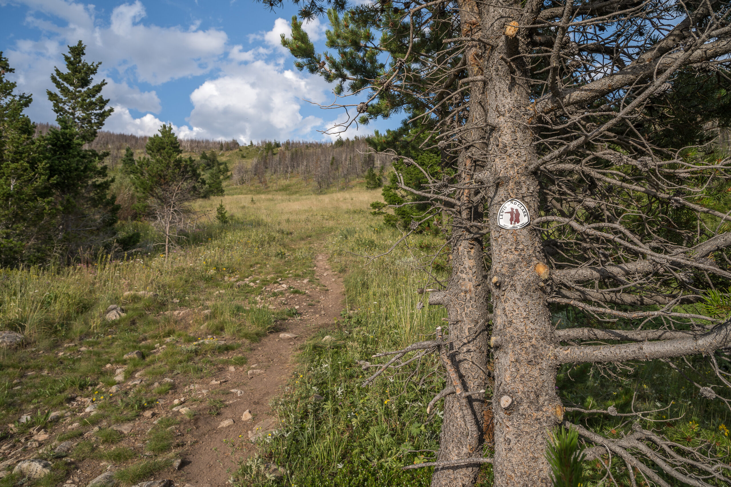
In 1806 as the Lewis and Clark expedition returned east from the Pacific Ocean, the party divided at what is now Traveler’s Rest State Park south of Missoula. Meriwether Lewis’ party embarked up the Blackfoot River toward what is now called Lewis and Clark Pass, having learned of it from the Nez Perce as a conduit from the mountains to the plains. Lewis wrote little about the low pass the Salish called Smítu Sx cu sí in his journal entries, mostly describing deer and beavers killed by the party for food.
But on July 7, Patrick Gas, a sergeant on the expedition, wrote “we proceeded on four miles up the branch, when we came to the dividing ridge between the waters of the Missouri and Columbia; passed over the ridge and came to a fine spring the waters of which run into the Missouri.”
Perched on the Continental Divide, that’s now a spot two national trails converge, and a place that’s remained near and dear to Mike Mueller’s heart since he shepherded the Green Mountain acquisition there in 2019. Purchased from a conservation-minded, multi-generation ranching family, it grew the HelenaLewis and Clark National Forest by 620 acres of habitat so superb that the project ranked ninth for the Forest Service’s national priority list for LWCF funding. Just north of Green Mountain sits 6,424-foot Lewis and Clark Pass where the Lewis and Clark National Historic Trail bisects the Continental Divide National Scenic Trail.
“We’re privileged to get to work in these places that have these amazing natural resources and also these historical values,” Mueller says. “And I’ll tell you what, it’s really important to landowners as well. They know what’s on that land—the elk habitat, the hunting opportunities, but also those historical aspects—and I want them to know that it’s all important to the Elk Foundation too. When you’re able to complete a project like this that has all these components, the next time something comes up, or another landowner reads about it, they want to work with the Elk Foundation again.”
Dan Wiley, manager of integrated resources stewardship for the National Park Service, says parcels like Green Mountain play an important part in keeping the corridor whole. The Lewis and Clark expedition sought to identify and record wildlife and landscapes, which they delivered to President Thomas Jefferson as a service to the people of the United States. RMEF’s work to keep the landscape as close to how Lewis and Clark and the Native Americans before them experienced it allows visitors to feel the same sense of awe and thrill of discovery, he says.
“The benefits the Rocky Mountain Elk Foundation brings to these public lands go well beyond just hunting and recreational opportunities,” Wiley says. “The more natural these lands are is directly relevant to the time period of the expedition. It’s that context that lets the American people appreciate what these landscapes were like prior to European contact.”
As they ascended the Blackfoot River toward Green Mountain, the expedition followed a wellworn path passing through traditional Salish-Pend d’Oreille territory that the Nez Perce called Qoq’aalx ‘lskit, Road to the Buffalo, which took hunting parties to the plains where the vast herds roamed. Using travois—a cart made from two poles dragged behind a horse—they traversed the pass, leaving deep ruts and an easy path for Lewis to follow. Other area tribes such as the Kootenai, Blackfeet, Crow and Shoshone used the trail as well.
With thousands of miles of national historic trails across the West, it’s inevitable RMEF projects will overlap in places to help preserve history and conserve the wildlife that inhabit them.
Between 1996 and 2000, RMEF purchased the Diamond and Pope ranches in southwest Wyoming. Now under BLM ownership, the ranches combine with adjoining public parcels to create a 14,000-acre block of winter range for the West Green River elk herd. And it so happens that a significant section of the Oregon Trail passes directly through the Pope Ranch here in the windswept hills of Wyoming.
The namesake of RMEF’s first acquisition, Robb Creek in southwest Montana, feeds the Ruby River and then the Missouri where the Lewis and Clark expedition spent more than a year exploring in 1806. Upon his return to St. Louis, Lewis recounted stories of abundant wildlife including deer, pronghorns, bears and elk.
RMEF worked with private landowners near Trinidad, Colorado, near the New Mexico border to conserve a half dozen properties through voluntary conservation agreements. That also happens to fall along the Santa Fe NHT used by both Mexican and American traders to move goods by oxen prior to the Mexican-American War in 1846. Post-war, the trail became a main artery to the Southwest until the first railroad reached Santa Fe in 1880.
Santa Fe Trail Association President Larry Short praises land conservation as an additional historic preservation tool to help build relationships between his group, private landowners and NPS which manages the trail.
“The goal is to protect, preserve and promote the Santa Fe National Historic Trail while respecting the rights of private landowners,” he says. “The opportunity to find additional methods to utilize the land and showcase the trails while protecting the natural integrity of the trails is welcomed by all of our trail partners.”
Whether consolidating checkerboarded landscapes or working with conservation-minded landowners, those charged with protection of historic trails believe the conservation work of RMEF and others will continue to foster a great partnership between habitat and history.
BLM’s Farley says federal agencies are currently pushing to inventory historic trail corridors, which will help with management decisions such as where to place infrastructure and areas to concentrate conservation work.
“It’s all about leveraging the partnerships, because what is good for the tribes is good for the elk is good for the historic , too,” she says.
Mueller echoes the need to leverage support from an array of interests and believes finding projects that provide multiple benefits will only continue to strengthen support for RMEF’s conservation work.
“When you look and see what’s happened in the West in the last four or five years, especially the amount of subdivision and population growth and the impacts on private lands and public lands, it’s never been more important to capture those really great pieces of wildlife habitat that have all the components: terrestrial, fisheries habitat benefits, access, recreation and these historic and cultural values before they’re all broken up,” Mueller says.